Kalaoa is the name you keep seeing on Zillow and Redfin for homes that everyone here would just call North Kona. It is a census name rather than a neighborhood, and its history is genuinely confusing: Kalaoa was a census designated place through the 2010 count, when it recorded 9,644 residents, and the Census Bureau reclassified it after 2020, by which point the area held 11,729 people. The listing portals kept using it anyway. So the label persists on real estate sites while almost nobody in Kona says it out loud.
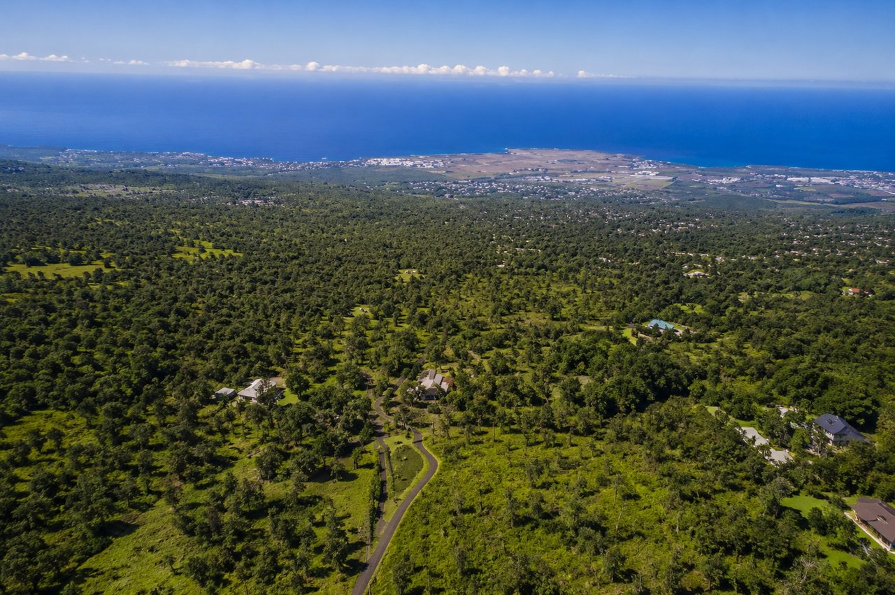
It is worth understanding rather than ignoring, because it covers a lot of ground. The Kalaoa area spans roughly 45 square miles on the lower western slopes of Hualālai, running from the shoreline up the mountain, bordered on the south by Kailua-Kona. Kona International Airport sits inside it. That is not a neighborhood. That is a quarter of the Kona coast.
If you are searching Kalaoa listings, what you are actually looking at is North Kona above and around the airport corridor, and the useful question is which part.
The Kalaoa area contains several distinct places that behave very differently in the market.
Closest to the highway and the airport are the hillside subdivisions along Kaiminani Drive, centered on Kona Palisades. Conventional house lots, paved streets, coastline views, and a short drive to town. This is where most of the ordinary residential inventory in the area sits.
Higher up the mountain is Kaloko, where the parcels become acreage, catchment replaces county water in most places, and the forest closes in. Three to five acres at the lower elevations, ten to twenty acres near the top.
Between and around them are smaller residential pockets and agricultural parcels that do not belong neatly to either. South of all of it, the slope runs down into Kailua-Kona proper.
Elevation is the organizing principle for the whole area. The official Kalaoa elevation figure is 680 feet, but that is a single reference point for a district that runs from the ocean to several thousand feet, and the difference between the bottom and the top is the difference between two climates.
Because the area spans so much ground, there is no meaningful single price for Kalaoa. A standard lot in a hillside subdivision and a twenty acre forested parcel at three thousand feet are both Kalaoa on a listing portal, and they have nothing in common as purchases.
Broadly, the subdivision inventory near the airport corridor is conventional single family housing at the middle of the Kona market, priced on view, elevation, and lot size. The upcountry acreage is a land market, priced on usable acres, access, water, and power rather than on square footage.
The practical implication is that comparable sales pulled on the Kalaoa label will be nearly useless. Compare within the specific subdivision or the specific elevation band. Live MLS data is the only reliable current reference, and our monthly Kona market update tracks North Kona activity more usefully than any static figure.
The defining feature of this area is access. Kona International Airport is inside it. The commercial corridor with Costco, Target, and the major shopping is along the highway at its lower edge. Honokōhau Harbor, Kaloko Honokōhau National Historical Park, and the beaches north toward Kekaha Kai are all close. Downtown Kailua-Kona is a short drive south.
Climate depends entirely on where you land. Down near the highway it is hot, dry, sunny, and windy. Up the slope it gets cooler and wetter fast, with afternoon cloud and real rainfall by the time you reach the upper elevations. Buyers routinely misjudge this because they toured at one elevation and assumed it applied to the whole area.
There is no town center here. The Kalaoa area has no village, no main street, no gathering place of its own. It is residential and agricultural land wrapped around an airport and a highway, and daily life means driving to Kailua-Kona or to the commercial corridor.
Establish which part of the area you are actually in. Subdivision, elevation, and road access will tell you more about a property than the Kalaoa label ever will. Ask that before anything else.
Confirm the water source. County water serves much of the lower and subdivision inventory, and catchment is standard higher up the mountain. This single fact changes the property, the maintenance, and the financing conversation. If it is catchment, inspect tank capacity, system condition, and filtration, and ask what the owners do in a dry stretch.
Confirm power and access. On acreage parcels, distance from the power line and the condition and ownership of the road are real costs. On subdivision lots, ask whether utilities are underground or overhead, which varies neighborhood to neighborhood.
Confirm every structure is permitted. Additions, ohana units, and owner built structures are common across North Kona, and unpermitted work affects financing, insurance, and what you can legally do later. Verify with the county Building Department.
Ask about wastewater. Septic and cesspool are both present. Hawaii requires cesspools to be upgraded, converted, or connected by 2050, so the system is either a future cost or a negotiating point.
Consider airport proximity deliberately. It is a convenience for frequent travelers and a noise question for some buyers. Visit the specific property at different times of day.
The area sits in Lava Zone 4 on the flank of Hualālai, the same designation as Kailua-Kona, Keauhou, and Holualoa, and a lower hazard rating than South Kona. Verify the zone on the specific parcel, since insurers and lenders look at it.
North Kona above the airport suits buyers who want proximity to everything with more space and better air than the coast offers. Whether that means a subdivision lot with a view or twenty acres of forest depends on how much land and how much self sufficiency you actually want, and those are two different searches inside the same search result.
It fits less well for buyers who want walkability, a town center, or a neighborhood identity. This area does not have one, which is part of why nobody calls it Kalaoa in conversation. Buyers who want that belong in Kailua-Kona, Keauhou, or Holualoa.
A census area name covering roughly 45 square miles of North Kona on the western slopes of Hualālai, from the shoreline up the mountain, including Kona International Airport. It was a census designated place through 2010 and was reclassified after the 2020 count. Listing portals still use the name, but residents do not.
No. It is a census label that contains several actual neighborhoods, including the Kona Palisades subdivisions along Kaiminani Drive and the acreage of Kaloko Mauka. Ask which subdivision and which elevation, not which census area.
North Kona, above and around the airport corridor, bordered on the south by Kailua-Kona. It runs from the ocean up the slope of Hualālai.
The lower and subdivision areas largely do. Higher up the mountain, catchment is standard. Confirm on the specific property, because within this area the answer changes with elevation.
12,165 people live in Kalaoa, where the median age is 44 and the average individual income is $46,265. Data provided by the U.S. Census Bureau.
Total Population
Median Age
Population Density Population Density This is the number of people per square mile in a neighborhood.
Average individual Income
There's plenty to do around Kalaoa, including shopping, dining, nightlife, parks, and more. Data provided by Walk Score and Yelp.
Explore popular things to do in the area, including Kona Airport Restaurant, Maxxwell's Landing, and Maxwell's Landing Restaurant.
| Name | Category | Distance | Reviews |
Ratings by
Yelp
|
|---|---|---|---|---|
| Dining · $$ | 1.53 miles | 55 reviews | 2/5 stars | |
| Dining | 1.53 miles | 0 reviews | 0/5 stars | |
| Dining | 1.57 miles | 5 reviews | 2.6/5 stars | |
| Dining | 1.57 miles | 7 reviews | 2/5 stars | |
| Dining · $$ | 1.58 miles | 12 reviews | 2.3/5 stars | |
| Dining | 1.59 miles | 4 reviews | 2.3/5 stars | |
| Dining | 1.7 miles | 0 reviews | 0/5 stars | |
| Dining | 1.7 miles | 0 reviews | 0/5 stars | |
| Dining | 1.77 miles | 0 reviews | 0/5 stars | |
| Dining | 1.81 miles | 0 reviews | 0/5 stars | |
| Dining | 2.6 miles | 0 reviews | 0/5 stars | |
| Dining · $$ | 2.68 miles | 35 reviews | 3.7/5 stars | |
| Active | 0.41 miles | 0 reviews | 0/5 stars | |
| Active | 1.33 miles | 1 review | 4/5 stars | |
| Active | 1.38 miles | 0 reviews | 0/5 stars | |
| Active | 2.2 miles | 0 reviews | 0/5 stars | |
| Active | 2.3 miles | 0 reviews | 0/5 stars | |
| Active | 2.31 miles | 16 reviews | 3.5/5 stars | |
| Active | 2.39 miles | 1 review | 5/5 stars | |
| Active | 2.41 miles | 0 reviews | 0/5 stars | |
| Active | 2.69 miles | 0 reviews | 0/5 stars | |
| Nightlife | 1.62 miles | 31 reviews | 2.8/5 stars | |
| Beauty | 2.12 miles | 0 reviews | 0/5 stars | |
| Beauty | 2.32 miles | 0 reviews | 0/5 stars | |
|
|
||||
|
|
||||
|
|
||||
|
|
||||
|
|
||||
|
|
Kalaoa has 4,084 households, with an average household size of 3. Data provided by the U.S. Census Bureau. Here’s what the people living in Kalaoa do for work — and how long it takes them to get there. Data provided by the U.S. Census Bureau. 12,165 people call Kalaoa home. The population density is 2,529 and the largest age group is Data provided by the U.S. Census Bureau.
Total Population
Population Density Population Density This is the number of people per square mile in a neighborhood.
Median Age
Men vs Women
Population by Age Group
0-9 Years
10-17 Years
18-24 Years
25-64 Years
65-74 Years
75+ Years
Education Level
Total Households
Average Household Size
Average individual Income
Households with Children
With Children:
Without Children:
Marital Status
Blue vs White Collar Workers
Blue Collar:
White Collar: