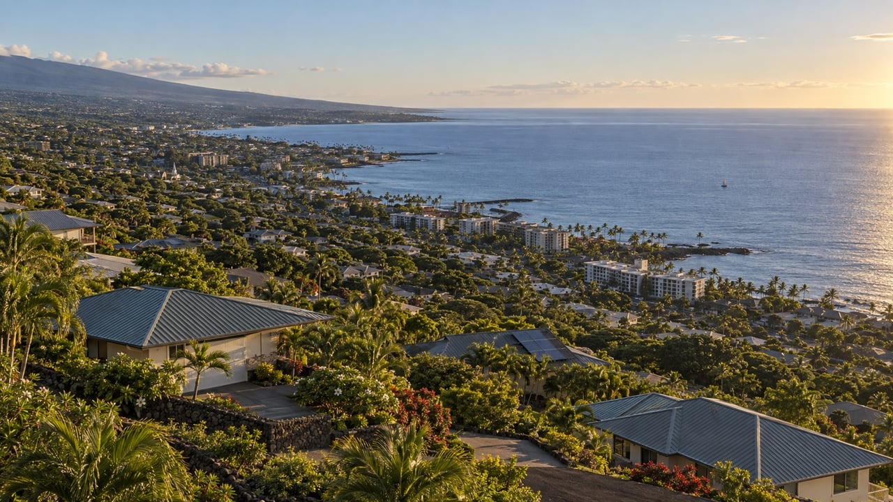
One of the things buyers new to the Kona market do not always expect is how much a few hundred feet of elevation can change a property. It changes the temperature, the rainfall, the cloud cover, the insurance requirements, and ultimately the price. Not just the view, though that changes dramatically too. In North Kona and the Kona Palisades, you can look at two homes a mile apart on a map and be comparing genuinely different living environments.
This post breaks down how elevation shapes the market in North Kona, what the tradeoffs are at each band, and what to check on any specific parcel before you write an offer. Whether you are looking at something near the coast in Kaloko, mid-slope in Kona Palisades Estates, or higher up in Kona Highlands, the elevation question is worth understanding before you start comparing prices.
Key Takeaways
- North Kona stretches from near sea level to roughly 1,500 to 1,800 feet on the slopes of Hualalai, creating meaningfully different microclimates within a short distance.
- Temperature drops approximately 3.5 degrees Fahrenheit per 1,000 feet of elevation gain. A mauka home in Kona Highlands can feel noticeably cooler than a coastal property below.
- Ocean views and coastal proximity generally command the highest prices. Mid-slope properties with partial views occupy the middle tier. Upper elevation trades views and convenience for space, cooler air, and often lower land cost per square foot.
- Hualalai's flanks including much of North Kona are mapped as lava hazard Zone 4. Confirm any parcel's zone before writing an offer. It affects insurance and financing.
- Coastal parcels require FEMA flood zone review. Mauka parcels require attention to site costs: driveways, drainage, retaining walls, and septic on steeper terrain.
- Visit properties at different times of day. Afternoon cloud cover patterns, wind, and solar exposure vary significantly by elevation and can only be understood on the ground.
The Elevation Range in North Kona
The Kona Palisades area above the airport runs from roughly 500 feet up to 1,500 to 1,800 feet on the slopes of Hualalai. That is the range where most of the residential communities sit: Kona Palisades Estates, Kona Highlands, Kona Acres, Kona Heavens, Pualani Estates, and the neighborhoods along the Lako Street corridor. Below that, the Kaloko area (the neighborhood north of town near the industrial corridor above Costco and Home Depot) sits closer to sea level before the terrain rises into the Palisades above it. Above the Palisades, the land gets steeper and more rural before transitioning to agricultural and forest zones.
Within that range, three broad bands behave differently in terms of climate, price, and practical ownership considerations. Coastal and low-elevation properties below roughly 500 feet, including the Kaloko area north of town. Mid-slope properties in the 500 to 1,200 foot range where most of the Palisades subdivisions sit. And upper elevation properties above 1,200 feet where Kona Highlands and the higher Palisades communities are found. None of these is a hard boundary. Elevation effects are gradual, but they are useful frames for thinking about tradeoffs.
How Climate Changes With Elevation
Temperature drops approximately 3.5 degrees Fahrenheit per 1,000 feet of elevation gain. That is a standard atmospheric rule of thumb and it holds reasonably well on Hualalai's slopes. A home at 1,500 feet will typically feel five or six degrees cooler than a property at 200 feet on the same day. That affects air conditioning use, nighttime comfort, and how the property feels year-round. That is a real quality of life consideration, not just a data point.
Rainfall increases with elevation on Kona's leeward side. The coast is relatively dry. Mid-slope areas receive more afternoon showers. The upper Palisades and Kona Highlands get noticeably more rain, which is why the vegetation is greener and denser up there. More rainfall means lusher landscaping and lower irrigation costs, but it also means more maintenance: faster growth, more erosion attention on sloped lots, and wetter conditions that can affect exterior surfaces over time.
Afternoon cloud cover is a real factor at higher elevations that buyers sometimes underestimate. Clear mornings with ocean views are common across the Palisades. Afternoons often bring clouds that build on the slopes, which can partially obscure views and reduce solar output for photovoltaic systems. Many buyers prefer the cooler, cloudier afternoons to relentless sun. But it is worth experiencing in person before you buy. Visit at different times of day and in different seasons if you can. For more on how the elevation microclimate actually feels day to day, see our guide to living at elevation in North Kona.
Vog is a separate consideration. When Kilauea is active and winds push volcanic haze toward the Kona coast, leeward areas including North Kona can be affected. Vog episodes are episodic and wind-dependent rather than constant, but buyers with respiratory sensitivities should be aware of it and ask about local patterns during due diligence.
How Elevation Shapes Prices
Ocean views and coastal proximity drive the highest prices in North Kona. A clear, unobstructed ocean view from a Palisades property adds meaningful value relative to an equivalent home without one. How much depends on the specific view, the lot position, and what comparable sales in that sub-area show. Partial views occupy a middle tier. Properties tucked into the slope without a view trade that premium for other attributes: more land, more privacy, cooler temperatures, and often lower price per square foot. For a deeper look at how buyers weigh these tradeoffs, see our post on oceanfront vs. mauka living in Kona.
Access and convenience factor in as well. Properties closer to town, the airport, and the commercial corridor along Queen Kaahumanu Highway tend to attract buyers who value that proximity: retirees who want to be close to medical services, buyers who travel frequently, people who just want Costco to be a ten-minute drive. Properties higher up the slope trade some of that convenience for space and quiet. The market prices that tradeoff differently depending on the buyer pool at any given time. If you are relocating from the mainland and weighing neighborhood options across Kona, our Kailua-Kona relocation guide covers what mainland buyers most commonly get wrong about the market.
Across North Kona the price range is wide. Older inland properties without views can trade well under $500,000. Luxury view properties in gated communities or with significant ocean frontage reach into the multimillion range. The mid-Palisades, the core of Kona Palisades Estates and similar subdivisions, occupies the middle of that spectrum with prices that vary significantly based on lot size, view, condition, and whether the property has been updated. Current data matters more than generalizations here. Verify active and recent closed sales for any specific sub-area before you form a price expectation.
Hazard Zones and What They Mean Practically
Hualalai's flanks, including most of North Kona, are mapped as lava flow hazard Zone 4 by the USGS Hawaiian Volcano Observatory. Zone 4 covers areas on the flanks of Hualalai that have been affected by lava flows in the last few centuries. It is not the highest-risk designation. Zones 1 and 2 cover the active rift zones of Kilauea and Mauna Loa. But it is a real consideration for lenders and insurers and needs to be confirmed for any specific parcel before you write an offer.
Lava zone affects insurance availability and cost. Some insurers exclude lava coverage in higher-risk zones or charge meaningfully different premiums. Lenders factor it into underwriting. Neither of these is typically a transaction-stopper in Zone 4, but knowing the zone early means you can get insurance quotes and confirm lender comfort before you are deep in escrow rather than after.
For coastal parcels, FEMA flood zone status applies separately from lava zone. Pull the address through FEMA's Map Service Center early in your search. If a property is in a Special Flood Hazard Area, lender-required flood insurance adds to your monthly carrying cost. Hawaii's sea level rise planning projections also factor in for coastal properties. Not an immediate concern for most buyers, but relevant for long-term risk planning and worth understanding.
Site Costs That Vary by Elevation
Coastal and low-elevation properties in North Kona, including the Kaloko area near the industrial corridor, tend to sit on flatter terrain with easier access, more established infrastructure, and shorter drives to services. The tradeoffs are salt exposure, which accelerates exterior wear, and flood and sea-level considerations for lower-lying parcels near the coast.
Mid-slope properties in the Palisades sit on moderately sloped terrain where most of the infrastructure is well-established. Drainage design matters more than at sea level, and some lots have retaining walls or grading considerations, but this is well-trodden ground for local contractors and inspectors. Many mid-slope communities in the Palisades have HOAs — before buying into any of them, see our guide to HOA fees in the Kona Palisades so you know what to review before you commit.
Upper elevation properties above 1,200 feet are where site costs can surprise buyers who do not ask the right questions. Steeper terrain means more expensive driveways: longer, steeper, and sometimes requiring more substantial paving or drainage features. Retaining walls are more common. Septic systems rather than county sewer are standard at higher elevations, and the design requirements on steeper lots can add cost. Wetter conditions mean faster vegetation growth and more active drainage management. None of this makes upper-elevation properties a bad buy. They often represent good value per square foot. But the total cost of ownership picture needs to include site-specific factors, not just the purchase price.
What to Check Before You Buy
Before writing an offer on any North Kona property, confirm the parcel's elevation and terrain using Hawaii County's TMK and property map tools. Verify the lava hazard zone on the USGS Hawaiian Volcano Observatory hazard map. Pull FEMA flood zone status for any coastal or low-lying parcel. Get insurance quotes early, homeowner, wind, and flood coverage where applicable, so cost and availability are not a surprise at closing. Ask about county water versus catchment or well, sewer versus septic, and driveway maintenance requirements. And visit the property at different times of day to understand the cloud cover, wind, and view patterns firsthand.
For buyers comparing properties across elevation bands, the most useful exercise is building a true total cost of ownership picture for each one: purchase price, carrying costs, insurance, site maintenance, and access considerations together. A coastal property and a Palisades property that look similar on the MLS may have meaningfully different cost profiles once those factors are mapped out side by side. If any property you are considering is listed as leasehold rather than fee simple, make sure you understand what that means before you write an offer. Our post on leasehold vs. fee simple in Kona covers the financing, cost, and resale implications in detail.
Frequently Asked Questions
How much cooler is a home in the Kona Palisades compared to the coast?
Roughly 3.5 degrees Fahrenheit cooler per 1,000 feet of elevation gain. A home at 1,500 feet in Kona Highlands will typically feel five to six degrees cooler than a property near the coast on the same day. That affects air conditioning use, nighttime comfort, and the overall feel of the property year-round.
Do ocean views significantly affect prices in North Kona?
Yes, meaningfully. Clear unobstructed ocean views command a premium over equivalent properties without them. The size of that premium depends on the specific view, lot position, and what comparable sales in that sub-area show. Partial views occupy a middle tier. Properties without views often trade at lower price per square foot but offer other attributes: more land, more privacy, cooler temperatures.
What lava hazard zone is North Kona in?
Most of North Kona and the Kona Palisades sits in lava flow hazard Zone 4, which covers the flanks of Hualalai that have been affected by flows in the past few centuries. Zone 4 is not the highest-risk designation, but it does affect insurance availability and lender underwriting. Confirm any specific parcel's zone on the USGS Hawaiian Volcano Observatory hazard map before writing an offer.
Are higher elevation lots cheaper to buy and own in the Palisades?
Land cost per square foot can be lower at higher elevations, but total cost of ownership is not necessarily less. Steeper terrain adds costs for driveways, retaining walls, drainage, and septic systems. Wetter conditions mean more active vegetation management. The purchase price may look attractive, but budget for the site-specific costs before you compare it directly to a flatter, lower-elevation property.
What utilities should I confirm for a North Kona property above the airport?
County water and sewer availability varies by parcel in North Kona. Many properties in the Palisades are on county water but use septic rather than sewer. Some more rural or upper-elevation parcels use rain catchment for water. Confirm the actual utilities for any specific property. Do not assume based on the general area. Ask your agent to pull utility confirmation early in due diligence.
What should sellers disclose about elevation-related factors in North Kona?
Parcel-specific information on lava hazard zone, FEMA flood status for coastal properties, utilities including water source and septic versus sewer, known site constraints such as drainage issues or retaining wall conditions, and any HOA rules affecting the property. Providing accurate disclosure documentation upfront protects both parties and keeps transactions moving cleanly through escrow.
If you are comparing properties across North Kona and want help mapping out what the elevation and site factors actually mean for a specific address, that is the kind of local knowledge that makes a real difference in this market. If you are still deciding between the Palisades and another part of North Kona, our post on choosing your Kona home base walks through how to compare the tradeoffs. Or reach out to us directly at Kona Homes for Sale or call 808-854-5432.
Mark Davis, Esq. is a licensed real estate broker (RB-23769) with Kona Homes for Sale at Coldwell Banker Island Properties, Kailua-Kona, Hawaii. He practiced as a transactional and litigation real estate attorney for 35 years before moving to the Big Island full time. He currently serves as a member of the Hawaii County Real Property Tax Board of Appeal.
Brenda Kuessner holds the ABR, CRS, e-PRO, GRI, and GREEN designations and has sold real estate on the Big Island for 35 years. Together they serve buyers and sellers across the Kona and Kohala Coast market. This post is for general informational purposes only and does not constitute legal or tax advice.